The solution radically transforms how field crews collect data especially on how they can safely and accurately capture data in hard-to-reach assets and in GNSS-impaired environments. When using an LTI laser rangefinder and an Eos Arrow Series GPS/GNSS receiver with Esri Collector for ArcGIS, a field worker can easily shoot, capture, and share high-accuracy 3D location data that is streamed into ArcGIS Online in real time.
At present, field crews are physically challenged in capturing accurate 3D locations for hard-to-reach assets. What they do is they would rely on a total station with a segmented software workflow. Then this workflow would require a meshing-together of the data back in the office.
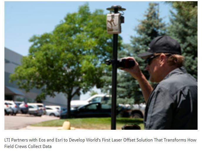
With the LTI + Eos + Esri laser offset solution, you get a seamless integration of these three technologies – LTI laser rangefinder, Eos Arrow Series GPS/GNSS receiver, and Collector for ArcGIS. The solution creates a total-station-like solution that enables field mapping crews to capture centimeter-accurate 3D locations of remote assets and in GNSS-impaired environments while reducing crew safety liabilities. The result is a high-functioning laser offset mapping tool. Field crews would no longer have to put themselves at serious risk of injury negotiating dangerous roadways, trenches, forests and urban canopies. Nor do they have to leave the Collector for ArcGIS and ArcGIS Online environments and never sacrifice accuracy. Hence, with the LTI-Eos-Esri laser offset solution, field crews can create precision mapping in a safer and more efficient workspace.
LTI President Eric Miller said “with Eos, the world’s leading manufacturer of high-accuracy GNSS receivers, Esri the global market leader in GIS software, and LTI the leading manufacturer of professional-grade laser rangefinders, it was a matter of time before this technology trifecta delivered something truly disruptive. We’re extremely proud of this partnership and this modern solution for the safest, most accurate asset-management workflows.”
LTI Senior Product Manager Derrick Reish said “by combining the high-accuracy of the Eos Arrow Series™ GNSS receivers and the laser capabilities of LTI, we can empower field crews to capture highly accurate XYZ coordinates from a safe distance. This eliminates the need for physically occupying every point. It also provides more accurate location data, with more affordable mobile asset-management workflows.”
Eos CTO Jean-Yves Lauture said “Eos is extremely grateful to be a part of this initial release in high-accuracy asset location data with LTI’s laser range finders and Esri’s Collector mobile app. Enabling this kind of accuracy means even the most budget-conscious field crews will be able to access the location of their hard-to-reach assets.”
Esri Product Manager Jeff Shaner said “Esri is extremely pleased that Collector can now support the capture of high-accuracy asset locations from afar, leveraging our unique partnership with both Eos and Lti. This is a game-changer for asset management.”Survey123 + Spike
Just last June 2018, Esri integrated Spike, a smart laser measurement solution, in Survey123 via a partnership with ikeGPS.
With Spike’s integration, Survey123 for ArcGIS users can now quickly, easily, and safely measure areas, heights, widths, and the offset location of assets that are difficult to reach, such as building or road signage, simply by taking a photo with a smartphone or tablet, all within the Survey123 for ArcGIS app.
To use the integrated solution, a field worker attaches the Spike laser device to a smartphone or tablet, opens the Survey123 for ArcGIS mobile app survey, and takes a photo. That photo, measurement data, and location data are then populated into the field worker’s survey form and uploaded into ArcGIS Online.
Spike provides a photo verifiable and authoritative record of the asset being measured, delivering increased confidence in field survey and measurements.