ArcGIS Online users can now work on their own private content directly within Microsoft Power BI using the built-in visualization software ArcGIS Maps for Power BI. By the way, Power BI is a suite of business analytic tools by Microsoft that delivers insights throughout an organization. Download free the Power BI Desktop here.
ArcGIS Maps for Power BI makes it easy to create beautiful, accurate map visualizations from within Power BI. Users can map data from any location value --- an address, city, province, ZIP code, place-name, boundary, or latitude and longitude --- with a simple drag-and-drop operation. They can then use smart map defaults that guide them to the right style and display for their data.
Power BI users can also take advantage of a vast selection of ready-to-use ArcGIS maps and demographic data as well as simple spatial analytics tools such as cross-filtering by map selection, heat maps, and drive times at no extra cost.
Esri product manager for ArcGIS Maps for Power BI said, ArcGIS users can [now] extend the reach of their authoritative location data from ArcGIS to their Power BI reports and dashboards.”
Also, Microsoft’s Senior Marketing Director for Power BI said “Microsoft Power BI, combined with Esri’s rich collection of ready-to-use geographic data and leading expertise in location intelligence, gives our mutual customers a way to make informed, location-based decisions. When you are able to turn on location data across an organization with one flip of the switch, the impact is significant.”

To learn more about Esri's ArcGIS Maps for Power BI or to see how it works, visit go.esri.com/powerbi. Also, go here to watch video about ArcGIS Maps for Power BI. And, GET STARTED with ArcGIS Maps for Microsoft Power BI here.
Esri + European Space Agency
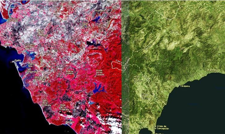
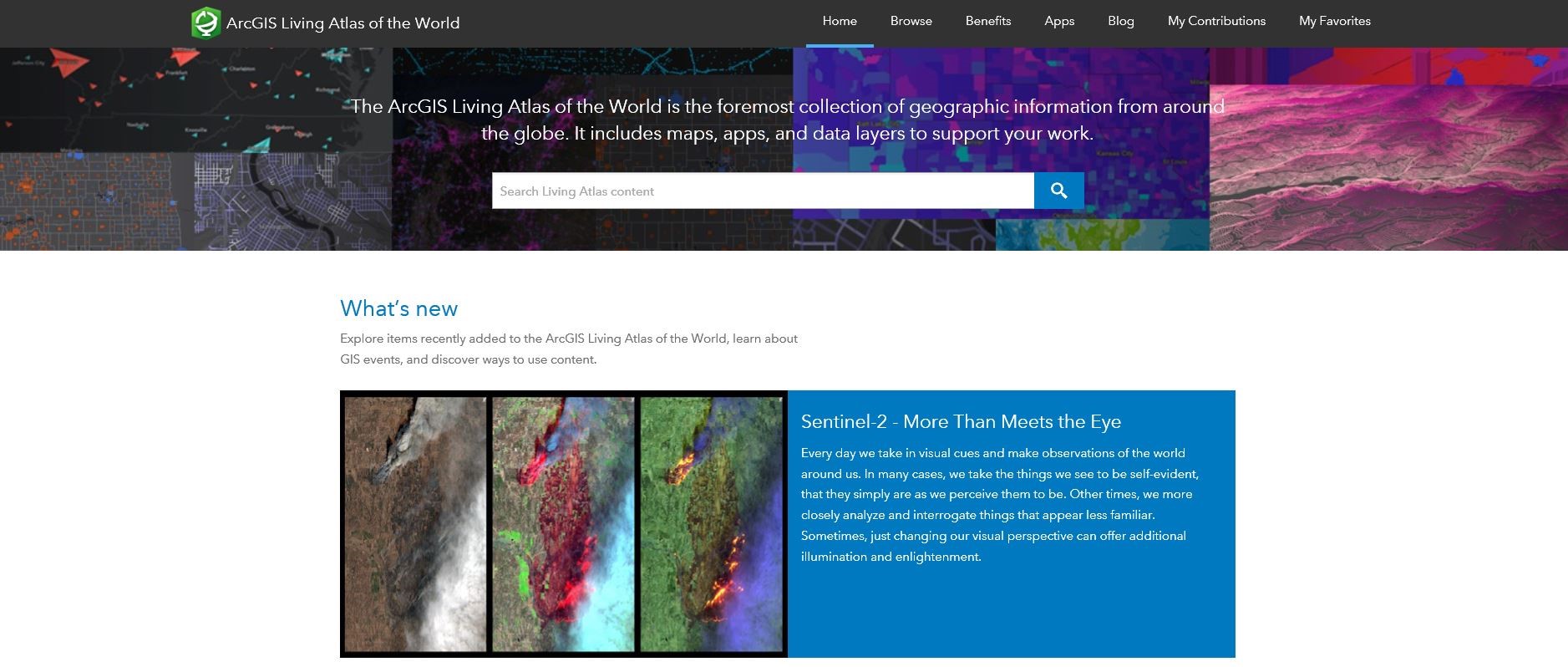
Esri is releasing Sentinel-2 Image Services to all Esri users for no additional cost. Currently in beta, Sentinel-2 Services is updated daily with new imagery for all-ground locations every 5 to 7 days. Sentinel-2 Image Services provide temporal, multi-spectral imagery of the entire globe for improved monitoring of agricultural and forest conditions, monitoring of land cover changes, and to assist with natural disaster management.
Esri President Jack Dangermond said “we are committed to helping pour users discover, explore, and better understand our changing planet. Pairing Sentinel-2 imagery with our ArcGIS Image Server provides a powerful platform for in-depth analysis which can inform meaningful action.”
Esri makes the Sentinel-2 multi-spectral data quickly accessible using ArcGIS Image Server and publishes an image services (Sentinel-2 Image Services) through the ArcGIS Living Atlas of the World, hosted on the Amazon Web Services Infrastructure. The Living Atlas is included with all ArcGIS Online subscription. If you are new to ArcGIS Online, try it free for 21 days by signing in here. For Esri users, image analysis can be run directly on the service to create indexes displaying properties such as vegetation health or soil moisture as well as quantifying the changes over time, for better understanding of the environment. For more information on the Living Atlas, visit go.esri.com/Sentinel. Or, read Robert Waterman’s blog to know more about Sentinel-2 in the Living Atlas.
Sentinel-2 is an Earth Observation Satellite that provides multi-spectral imagery for any location in the world at 10-meter resolution. It is part of Copernicus, the world’s largest single Earth observation program directed by the European Commission in partnership with the European Space Agency.
Esri + SAP HANA
In early January 2018, SAP SE announced that Esri will support the SAP HANA platform to ‘geo-enable the intelligent enterprise’. This is now real after Esri announced this June 2018 that it is integrating ArcGIS software into SAP HANA. SAP HANA is SAP’s latest cloud-based offering to help customers create location-aware business applications faster.
Esri supports SAP HANA as an enterprise geodatabase with the recent release of ArcGIS 10.6 and ArcGIS Pro 2.1. (Get the trial here free for 21 days if you are new to ArcGIS.)
The new SAP HANA offering enables businesses to process location data such as complex imagery, visualize and analyze their authoritative data in a geospatial context. Also, users can now deliver their data through consumer-friendly maps; integrate the results into custom business applications; create models that efficiently process streams of earth observation data such as water content or soil temperatures and see this data on high-quality basemaps on ArcGIS Online.
Bernd Leukert, member of the Executive Board of SAP SE, Products & Innovation, said “we have many customers running SAP, non-SAP and Esri solutions. They will now be able to streamline their IT architecture with one underlying platform powered by SAP HANA. This will not only support immediate return on investment by reducing redundancies and improving performance, but also pave the way for further innovation by connecting GIS and enterprise systems and data.”
Likewise, by leveraging Esri technology in SAP HANA, businesses and organization can now extract high-value business information from satellite, drone, and open data sources and then easily discover and share location-based insights.
Esri President Jack Dangermond said “GIS and mapping combined with the richness of business data and business processes is a very powerful combination that can benefit every industry. Together, SAP and Esri are making GIS, mapping, advanced visualizations and spatial analytics available to everyone across the enterprise.”
To learn more about Esri's offerings for customers running SAP solutions, visit go.esri.com/sap-hana.

Esri + Gulf Energy Information
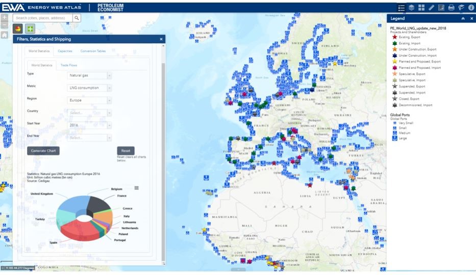
This June 2018, the Esri + Gulf Energy Information partnership brings the Energy Web Atlas to ArcGIS users and to ArcGIS platform. The Energy Web Atlas data covers pipelines, gas processing facilities and LNG projects. With the partnership, the Esri community can examine real-time project information, explore data and share location-based insights, export and manipulate data, and serves as a comprehensive source of actionable project intelligence.
The Energy Web Atlas tracks more than 500 LNG facilities/projects and over 3,670 gas pipelines (existing, planned and under construction) globally. In addition, the platform’s North American gas processing dataset includes comprehensive data on more than 600 gas processing plants, 510 existing natural gas pipelines, more than 1,300 gas compressor stations, 400-plus natural gas underground storage locations and 58 natural gas market hubs.
Gulf Energy Information’s Director of Data Services Scott Allgood said “the Esri partnership gives us the ability to better collaborate with industry leaders and brings our offerings to a wider audience base, while continuing to work closely with Esri’s architecture and future development.”
Esri’s Partner Executive-Natural Resources Paul Hartwell added that “we are pleased to. . .join the Esri Partner Network and offer their industry leading content and insight through Energy Web Atlas to the GIS user community and beyond. Their wealth of data on LNG, natural gas and other energy projects around the world is of unique value to customers assessing strategic projects and investments.”

Esri + ikeGPS
Spike comes officially in Esri’s Survey 123 for ArcGIS after a new distribution agreement was recently forged between ikeGPS and Esri. The agreement makes Spike available to Esri’s U.S. user community (as of the moment).
Spike is a smart laser measurement solution which integrates with Esri’s Survey123 for ArcGIS. With Spike’s integration, Survey123 for ArcGIS users can now quickly, easily, and safely measure areas, heights, widths, and the offset location of assets that are difficult to reach, such as building or road signage, simply by taking a photo with a smartphone or tablet, all within the Survey123 for ArcGIS app.
To use the integrated solution, a field worker attaches the Spike laser device to a smartphone or tablet, opens the Survey123 for ArcGIS mobile app survey, and takes a photo. That photo, measurement data, and location data are then populated into the field worker’s survey form and uploaded into ArcGIS Online.
Spike provides a photo verifiable and authoritative record of the asset being measured, delivering increased confidence in field survey and measurements.
Spike and Survey123 for ArcGIS fill the need for a complete end-to-end workflow, and one that is entirely mobile and easy to deploy, for field data collection.
ikeGPS CEO Glenn Milnes said, Esri is not only the GIS market leader, they are a trusted voice for new technology that can benefit organizations that relay on field activities and bring efficiencies to their day-to-day processes. In addition to recognizing the value of integrating Survey 123 for ArcGIS with Spike, Esri wanted to directly bring this powerful joint-solution to their domestic user community.
For more information on Spike and Survey123 for ArcGIS, visit ikegps.com/esri-survey123.